Announcement

Collapse
No announcement yet.

GPS tips and questions

Collapse
X
 
  • Filter
  • Time
  • Show
Clear All
new posts

  • #31
    Terese, if you plug in Vernon and Kay's new address, your
    GPS will tell you to make a left turn up the concrete drainage ditch. And,
    sometimes it will tell you to turn into somes narrow gravel driveway. It will even send you along 12 miles of deep loose gravel on the way to Vetches.

    So, if you are up for an adventure, just turn on your GPS, punch in some directions and follow along.
    Bob Steber
    1995 R100GSPDC Long Tall Sallie
    1991 R100GS The Bumblebee
    1976 R90s Odalisque

    Comment


    • #32
      Originally posted by dixieoutlaw View Post
      I want this thread to be an educational one where we can offer our info on how we use our GPS and little tips that help us in our planning and usage. Would also be a good place for anyone to ask a question on how to do something with the GPS. I do not want it to be brand specific, as I am sure most of the info will bridge the brand gaps.
      Maybe the modetrator could make this a sticky?

      First tip.

      When planning my routes in Mapsource, I place the via points (waypoints) just beyond the intersection. By doing this my directional arrow will point to the way I need to turn or straignt ahead if no turn. and the prompt tells me to which way to turn. Before using this method, I would place my via point right in the intersection and several times I found myself pulling over to determine where I needed to go after arriving at that via point.

      Let's hear from the others out there - we all all in a learning stage.

      Gary
      Here's a tip....follow someone who knows where the heck their going.

      Comment


      • #33
        Tom,
        next time you lead on one of our long, wild, late runs.
        Gary
        Charm and Mr. Congeniality

        Comment


        • #34
          Originally posted by dixieoutlaw View Post
          Tom,
          next time you lead on one of our long, wild, late runs.
          Gary
          Awright. I found my disk. later......

          Comment


          • #35
            Gary.

            Very good suggestion for waypoint placement.

            It is also important to reduce the scale to the lowest possible setting in order to make sure the placement is accurate. If a waypoint is set at .1 mile scale, or more, it could possibly be off that much and upon arrival , your unit will direct you to make an unnecessary or incorrect turn.


            Bob
            Bob Steber
            1995 R100GSPDC Long Tall Sallie
            1991 R100GS The Bumblebee
            1976 R90s Odalisque

            Comment


            • #36
              Using .gpx files to exchange GPS info

              Steve S. has changed the forum to allow us to attach more file types. Two of these new types are Mapsource .gdb files and an exchange format called gpx files. What does this do for us?
              If you are a Garmin GPS user and want to post your routes, waypoints and tracks on ther forum for others to use now you can attach these .gdb files as part of your post. (See Steve's instructions over on the ABEES test post thread on how to do this.) Only problem with this not everyone has a Garmin GPS. So if you are a Tomtom or other brand GPS user these posts are basically useless to you. How can everyone wanting to benefit from these posts. Simply, after you save your file in its native format, then go back and do a "Save as" and select .gpx as the file format. After saving the file in the .gpx format now attach it to your post. If you are reading a post and see a .gpx file as an attachment, you should be able to click or double-click this file and it will open you GPS mapping software (Mapsource in my case.)
              Because of the limited amount of storage the forum is allowed, I don't think we should post every trip we do. However, if yo have really found a nice ride please post it as a .gpx file. Please do not post the file containing your maps, only waypoints, routes and tracks. Maps just take up too much space and they will not be useful to the person downloading since each GPS requires its own unlock code or specific type of format.

              Hope this helps and as a starter I am posting my GPS files from yesterday's ride to Welcome Falls as a .gpx file to let you experiment.

              Gary
              Last edited by dixieoutlaw; 01-13-2008, 03:26 PM. Reason: no attachment
              Charm and Mr. Congeniality

              Comment


              • #37
                Try attachment again

                Not sure why the file did not attach, but will try again.
                Gary
                Charm and Mr. Congeniality

                Comment


                • #38
                  Thanks Gary. Your information is a big help!

                  bob
                  Bob Steber
                  1995 R100GSPDC Long Tall Sallie
                  1991 R100GS The Bumblebee
                  1976 R90s Odalisque

                  Comment


                  • #39
                    Yeah, but I ain't got the file to attach yet. At least it's not showing on my computer. so one try then I pass this off to Steve. Think the lesson is I didn't pay attentionto the file size allowed and I had to delete my routes and a couple of other tracks to get it to fit.
                    bob, don't know if you all-around alabama file will fit or not
                    gary
                    Charm and Mr. Congeniality

                    Comment


                    • #40
                      Steve need help

                      Steve need help here. the GPX file is not attaching. would you try one and then tell me what I am doing wrong.
                      Gary
                      Charm and Mr. Congeniality

                      Comment


                      • #41
                        Gary,

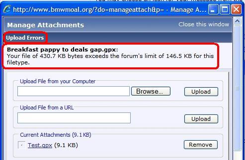
                        I uploaded a GPX file with no problem. I suspect the file you attempted to upload exceeded the file size limit of 146kb. You should have received an error at the top of the Manage Attachment screen when you attempted to upload the file (see image below). I converted a file from GDB to GPX and the GPX file was more than 4 times larger.


                        Let me know the typical size of GPX files and I can change the limits if they are not too large.
                        Attached Files
                        Steve Schuckman
                        2002 K1200RS Ice Blue/Marrakesh
                        2015 Mercedes SLK350

                        Comment


                        • #42
                          Good thing you tried it out before telling everyone that they could get the files here.

                          I wonder, if we converted the All Around Alabama XL file to a .pdf file, would it work then?

                          Hopefully, Steve can do his thing and make this a go.

                          Thanks again.

                          Bob
                          Bob Steber
                          1995 R100GSPDC Long Tall Sallie
                          1991 R100GS The Bumblebee
                          1976 R90s Odalisque

                          Comment


                          • #43
                            attachment of gpx file

                            Here is my final attempt to attach the gpx file of my ride to Welcome and Thompson falls. I will also attach it as a Garmin .gdb file. Because of the significantly larger file size of the .gpx file. I recommended to Steve that maybe we only allow GPS files in their native format, ie. .gdb for Garmin to be uploaded. If any member wishes the file in a .gpx format for loading on a none Garmin GPS, then we can attach the .gpx file to a normal email and send it to that member.

                            Thanks for bearing with us as we sort this out. Once we have it all down to a fine science I think we will all benefit, and then we can come up with something else to confuse the hell out of everyone.

                            Gary
                            Attached Files
                            Charm and Mr. Congeniality

                            Comment


                            • #44
                              Gary.

                              the .gpx file did not open. I got a screen with links to purchase software that would open the file. My Zumo software is on this computer.

                              The other file worked perfectly, and I must learn how to do the track insert.

                              Thanks for all of your work. I look forward to being confused on you next project.
                              Bob Steber
                              1995 R100GSPDC Long Tall Sallie
                              1991 R100GS The Bumblebee
                              1976 R90s Odalisque

                              Comment


                              • #45
                                Gary,

                                Both files opened fine with Mapsource. The GPX file contained 5 waypoints and 1 track but it did not contain any routes. The GDB file contained waypoints, tracks and a route.
                                Steve Schuckman
                                2002 K1200RS Ice Blue/Marrakesh
                                2015 Mercedes SLK350

                                Comment

                                Working...
                                X